File:Viu de Llevata, Alta Ribagorça. Església de Sta. Maria (A-SiT D9236).jpg
.jpg)
.jpg&action=edit&redlink=1)
No higher resolution available.
Viu_de_Llevata,_Alta_Ribagorça._Església_de_Sta._Maria_(A-SiT_D9236).jpg (451 × 600 pixels, file size: 120 KB, MIME type: image/jpeg)
.jpg)
Summary
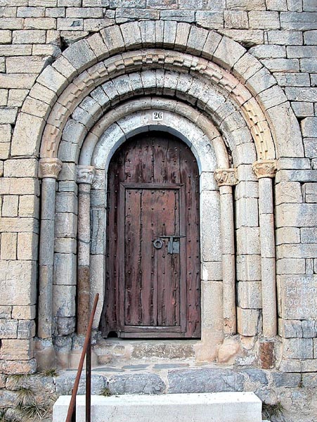
| Description |
Català: Viu de Llevata, municipi del Pont de Suert, Alta Ribagorça, Catalunya. Església parroquial de Santa Maria, portada. Romànic llombard, segle XII. Español: Viu de Llevata, municipio de Pont de Suert, Alta Ribagorça, Cataluña. Iglesia parroquial de Santa María, portada. Románico lombardo, siglo XII. English: Viu de Llevata, municipality of El Pont de Suert, Alta Ribagorça, Catalonia. Church of Santa Maria, portal. Lombard romanesque, twelfth century.
|
||
| Date | |||
| Source | Own work | ||
| Author | Fotoarxiu.sarratetorres |
| Object location | | View this and other nearby images on: OpenStreetMap |
|---|
.jpg¶ms=042.369462_N_0000.812408_E_globe:Earth_class:object_region:ES-CT_type:landmark_source:cawiki_&language=en)
Licensing
I, the copyright holder of this work, hereby publish it under the following license:
This file is licensed under the Creative Commons Attribution-Share Alike 3.0 Unported license.
- You are free:
- to share – to copy, distribute and transmit the work
- to remix – to adapt the work
- Under the following conditions:
- attribution – You must give appropriate credit, provide a link to the license, and indicate if changes were made. You may do so in any reasonable manner, but not in any way that suggests the licensor endorses you or your use.
- share alike – If you remix, transform, or build upon the material, you must distribute your contributions under the same or compatible license as the original.
File history
Click on a date/time to view the file as it appeared at that time.
| Date/Time | Thumbnail | Dimensions | User | Comment | |
|---|---|---|---|---|---|
| current | 16:44, 13 January 2012 | | 451 × 600 (120 KB) | wikimediacommons>Fotoarxiu.sarratetorres |
File usage
The following pages on the English Wikipedia link to this file (pages on other projects are not listed):
.jpg)