File:US Secession map 1861.svg

Size of this PNG preview of this SVG file: 787 × 483 pixels. Other resolutions: 320 × 196 pixels | 640 × 393 pixels | 1,024 × 628 pixels | 1,280 × 786 pixels | 2,560 × 1,571 pixels.
Original file (SVG file, nominally 787 × 483 pixels, file size: 111 KB)
Summary
{{Information
|Description=
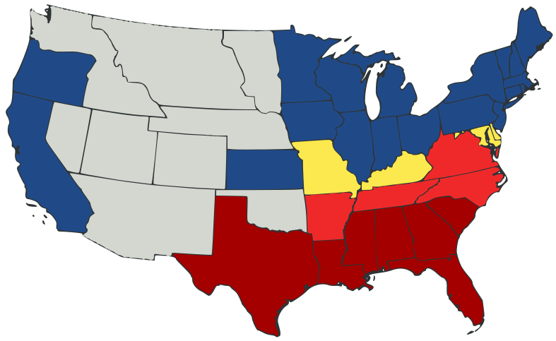
English: United States map of 1861, showing affiliation of states and territories regarding secession from the Union at the start of the American Civil War.
Legend:
States that seceded before April 15, 1861
States that seceded after April 15, 1861
States that permitted slavery, but did not secede
States of the Union where slavery was banned
U.S. territories, under Union Army control
|Date=2007-02-23
|Source=
A trace, retouch, and recolour of Image:Secession Map of the United States, 1861.png by User:Tomf688.
|Author=[[User:ions= |Other fields= }}
Licensing
This file is licensed under the Creative Commons Attribution-Share Alike 3.0 Unported license.
- You are free:
- to share – to copy, distribute and transmit the work
- to remix – to adapt the work
- Under the following conditions:
- attribution – You must give appropriate credit, provide a link to the license, and indicate if changes were made. You may do so in any reasonable manner, but not in any way that suggests the licensor endorses you or your use.
- share alike – If you remix, transform, or build upon the material, you must distribute your contributions under the same or compatible license as the original.
File history
Click on a date/time to view the file as it appeared at that time.
| Date/Time | Thumbnail | Dimensions | User | Comment | |
|---|---|---|---|---|---|
| current | 23:47, 23 February 2007 | | 787 × 483 (111 KB) | wikimediacommons>Tintazul | {{Tintazul |Description=United States map of 1861, show affiliation of states and territories regarding the Secession War (Civil War.) Legend: {{legend|#A40000|States that seceded before April 15, 1861}} {{legend|#EF2929|States that seceded after April 15 |
File usage
The following pages on the English Wikipedia link to this file (pages on other projects are not listed):
Global file usage
The following other wikis use this file:
- Usage on ar.wikipedia.beta.wmflabs.org
- Usage on es.wikipedia.beta.wmflabs.org