File:Felix 2007-09-03 1138Z.jpg

Size of this preview: 800 × 545 pixels. Other resolutions: 320 × 218 pixels | 640 × 436 pixels | 1,024 × 698 pixels | 1,280 × 873 pixels | 2,772 × 1,890 pixels.
Original file (2,772 × 1,890 pixels, file size: 824 KB, MIME type: image/jpeg)
|
Summary
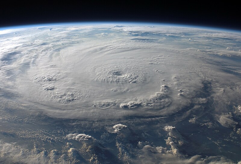
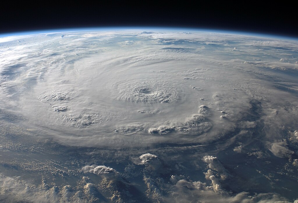
| Description | ISS015-E-25049 (3 Sept. 2007) --- This view of Hurricane Felix was taken from the Earth-orbiting International Space Station by an Expedition 15 crewmember using a digital still camera equipped with a 28-70 mm lens set at 28 mm focal length on Sept. 3, 2007 at 11:38:46 GMT. The ISS was located at the nadir point of 16.9 degrees north latitude and 83.3 degrees west longitude, over the waters southwest of Grand Cayman Island. At approximately noon GMT, Hurricane Felix was near 14.2 degrees north latitude and 76.9 west longitude, about 260 miles (425 kilometers) south of Kingston, Jamaica, and 425 miles (685 kilometers) east of Cabo Gracias a Dios on the Nicaragua/Honduras border, moving west at 21 miles per hour (33 kilometers per hour). The sustained winds were 165 miles per hour with higher gusts making it a category 5 on the Saffir-Simpson Hurricane Scale. | |||||
| Date | ||||||
| Source | http://www.nasa.gov/mission_pages/station/multimedia/exp15_hurricane_felix.html | |||||
| Author | NASA | |||||
| Permission (Reusing this file) |
|
|||||
| Other versions |


This image or video was catalogued by one of the centers of the United States National Aeronautics and Space Administration (NASA) under Photo ID: ISS015-E-25049. This tag does not indicate the copyright status of the attached work. A normal copyright tag is still required. See Commons:Licensing. Other languages:
|
File history
Click on a date/time to view the file as it appeared at that time.
| Date/Time | Thumbnail | Dimensions | User | Comment | |
|---|---|---|---|---|---|
| current | 21:21, 20 September 2007 | | 2,772 × 1,890 (824 KB) | wikimediacommons>Good kitty | cropped this again |
File usage
No pages on the English Wikipedia link to this file. (Pages on other projects are not counted.)