File:ElectoralCollege2008.svg

Original file (SVG file, nominally 1,020 × 593 pixels, file size: 29 KB)

Summary
| U.S. presidential election maps (SVG) |
| See also: National Atlas maps (png) |
|
1789 · 1792 · 1796 · 1800 · 1804 · 1808 · 1812 · 1816 · 1820 · 1824 · 1828 · 1832 · 1836 · 1840 · 1844 · 1848 · 1852 · 1856 · 1860 · 1864 · 1868 · 1872 · 1876 · 1880 · 1884 · 1888 · 1892 · 1896 · 1900 · 1904 · 1908 · 1912 · 1916 · 1920 · 1924 · 1928 · 1932 · 1936 · 1940 · 1944 · 1948 · 1952 · 1956 · 1960 · 1964 · 1968 · 1972 · 1976 · 1980 · 1984 · 1988 · 1992 · 1996 · 2000 · 2004 · 2008 · 2012 · 2016 · 2020 · 2024 |
| Description |
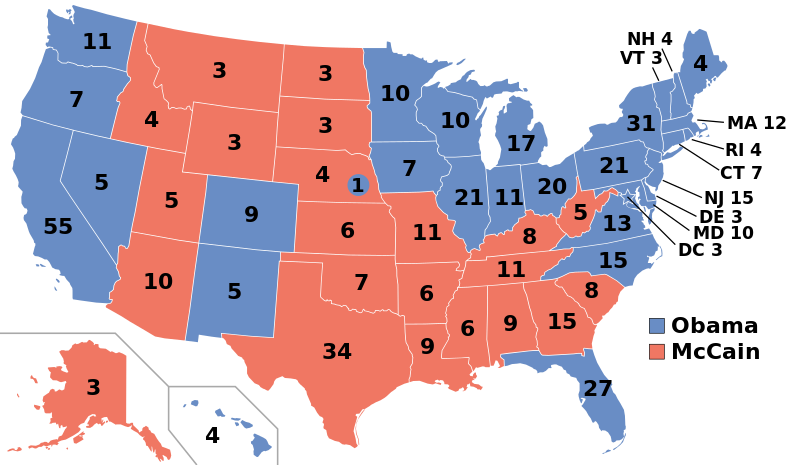
English: Electoral college map for the 2008 United States presidential election (note: Nebraska and Maine split their EVs by congressional district).
Please only update the map when a state is projected SAFE after the final polling place is closed. Do not crystal ball the results. Wait until at least three news organizations call a state before changing the colour: see Pollster.com to see who has called what. Sources used: Pollster.com, CNN.com, MSNBC.com, AP.org, FOXNews.com, and the Omaha World Herald |
||
| Date | |||
| Source | Own work | ||
| Author | Gage | ||
| Permission (Reusing this file) |
|
||
| SVG development | This map was created with an unknown SVG tool. |
File history
Click on a date/time to view the file as it appeared at that time.
| Date/Time | Thumbnail | Dimensions | User | Comment | |
|---|---|---|---|---|---|
| current | 04:19, 23 December 2020 | | 1,020 × 593 (29 KB) | wikimediacommons>Politicsfan4 | changed placement of Nebraska's electoral votes for consistency with 2020 map. |