File:Dioecesis Thraciae 400 AD.png
No higher resolution available.
Dioecesis_Thraciae_400_AD.png (461 × 352 pixels, file size: 205 KB, MIME type: image/png)
Summary
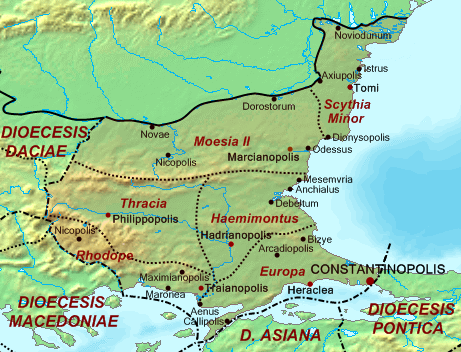
| Description | Map of the Diocese of Thrace (Dioecesis Thraciae) ca. 400 AD, showing the subordinate provinces and the major cities. |
| Date | |
| Source |
Base map found at en:Topographic map#Global 1-kilometer map, otherwise self-made. Data based on maps in atlases and the internet and on contemporary sources, primarily the Notitia Dignitatum. Note: The exact course of the provincial boundaries is very uncertain and in many cases only approximate. |
| Author | Cplakidas |
Licensing
| I, the copyright holder of this work, release this work into the public domain. This applies worldwide. In some countries this may not be legally possible; if so: I grant anyone the right to use this work for any purpose, without any conditions, unless such conditions are required by law. |
File history
Click on a date/time to view the file as it appeared at that time.
| Date/Time | Thumbnail | Dimensions | User | Comment | |
|---|---|---|---|---|---|
| current | 14:30, 20 May 2017 | | 461 × 352 (205 KB) | wikimediacommons>Julieta39 | Antic shoreline of the Danube mouths since Grigore Antipa's "Black Sea" (1940) and Andrei Nacu's paleomap [https://fr.wikipedia.org/wiki/Delta_du_Danube#/media/File:Danube_Delta_evolution.gif]. |
File usage
The following pages on the English Wikipedia link to this file (pages on other projects are not listed):